Pensacola Maps and Orientation
(Pensacola, Florida - FL, USA)
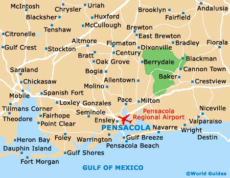
The most westerly of all the cities that make up the Florida Panhandle, Pensacola lies close to the border with
Alabama and within Escambia County, where it is the county seat. This sea port city resides alongside Pensacola Bay, which ultimately leads to the Gulf of Mexico.
High-rise condos and attractive white-sandy beaches make up much of the scenery of this seaside city, while two sizeable military bases also make their presence known.
The neighboring city of Gulf Breeze resides on the Fairpoint Peninsula, being directly to the south and connected by the Pensacola Bay Bridge / Gulf Breeze Parkway (US-98). Additional recreational opportunities present themselves if you head a little further south and across the Pensacola Beach Boulevard, to the Gulf Islands National Seashore, where natural beaches and wildlife reserves are in good supply.
Maps and Orientation of the City
Finding your way around the 'City of Five Flags' is straightforward, with downtown Pensacola being made up of a gridwork of blocks. Prominent thoroughfares intersecting the city center include the North Davis Highway, Dr. Martin Luther King Junior Drive and North Palafox Street, all of which head north to south, while Cervantes Street and West Garden Street run east to west.
For maps of the city, the bookstore on North Guillemard Street is of note, as is the Visit Pensacola Welcome Center on East Gregory Street. This dedicated pavilion-style building is located just off the Bayfront Parkway and comes with its own waterfront parking spaces and picnic tables.
- Bellview - 7 miles / 11 km (12 minutes, northwest)
- Brent - 4 miles / 6 km (ten minutes, north)
- Ensley - 8 miles / 13 km (15 minutes, north)
- Ferry Pass - 8 miles / 13 km (15 minutes, north)
- Gonzalez - 12 miles / 19 km (20 minutes, north)
- Goulding - 3 miles / 5 km (five minutes, north)
- Gulf Breeze - 7 miles / 11 km (12 minutes, south)
- Helmsfield - 13 miles / 21 km (25 minutes, northwest)
- Hickory Hill - 13 miles / 21 km (25 minutes, northwest)
- Milton - 23 miles / 37 km (35 minutes, northeast)
- Myrtle Grove - 6 miles / 10 km (12 minutes, west)
- Oriole Beach - 12 miles / 19 km (20 minutes, southeast)
- Panama City - 103 miles / 166 km (two hours and 40 minutes, southeast)
- Perdido Bay - 14 miles / 23 km (25 minutes, west)
- Turner's Meadow - 12 miles / 19 km (20 minutes, north)
- Warrington - 6 miles / 10 km (12 minutes, southwest)
Map of the United States

Map of Florida

Map of Pensacola